Hurricane Melissa: The Caribbean Is About to Experience a Storm of the Century
A Quick Ascent to a Catastrophic Hurricane Melissa
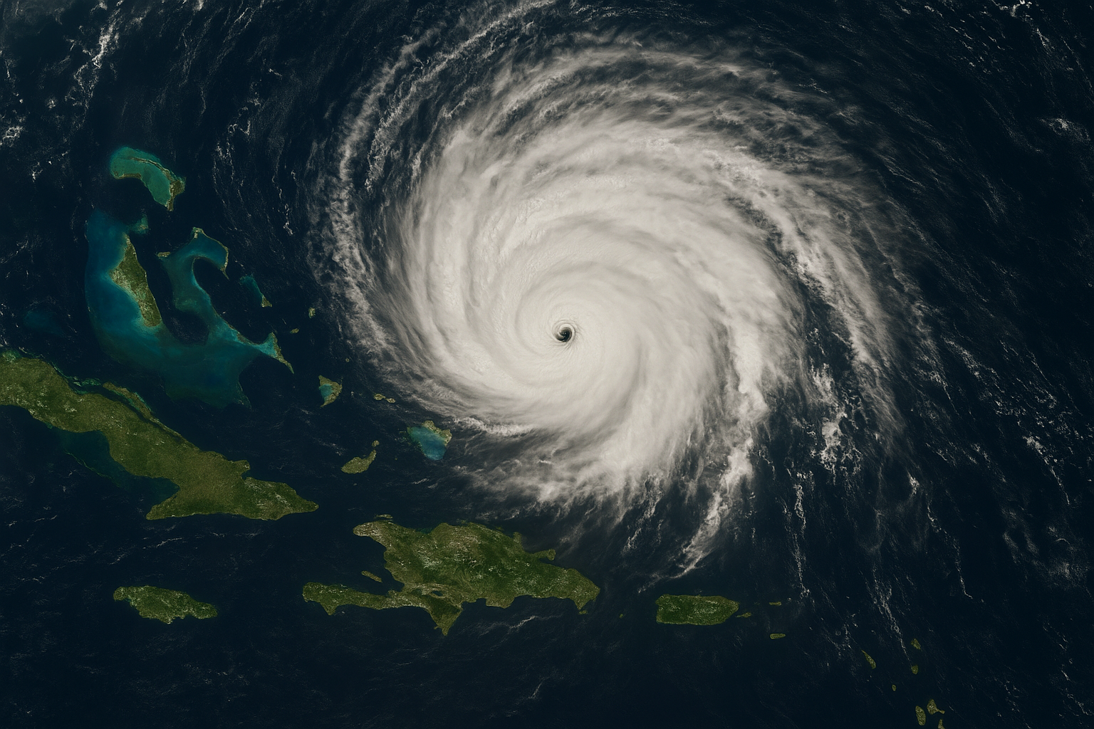
One of the most dangerous cyclones in recent memory has developed from what started out as a small tropical wave in the mid-Atlantic. In warm Caribbean waters, Hurricane Melissa quickly intensified after forming on October 21, 2025.
With sustained winds of about 185 mph and an abnormally low central pressure of about 892 millibars, it was a Category 5 storm by the time it made landfall close to Jamaica, making it one of the strongest Atlantic storms ever recorded.
One of the main causes of Melissa’s explosive intensification, according to meteorologists, is the unusually warm ocean temperatures, which are several degrees above average in the Caribbean.
Its potential for devastation was further increased by its slow motion over warm water; a storm that lingers over a region gives rain, winds, and surge more time to do their damage.


The Reasons Behind Jamaica’s Historic Hurricane Threat Melissa
The warnings were severe when Hurricane Melissa struck southwestern Jamaica on October 28. The situation was deemed “catastrophic” by officials.
Among the main dangers were:
- Wind: Damage to buildings, downed power lines, and uprooted trees were all but certain due to the island’s Category 5 winds.
- Rainfall: In many parts of Jamaica, forecasts called for 15 to 30 inches (≈400-760 mm) of precipitation, with isolated totals potentially reaching 40 inches, which would be sufficient to cause landslides and flash floods.
- Storm surge and waves: Large, destructive surf and surge heights of 8 to 12 feet above ground level were forecast for Jamaica’s south coast.
The prime minister of the island issued a warning:
- “Now is not the moment to show courage. Many of these communities won’t make it through the floods.
- Authorities declared a disaster, opened emergency shelters, and evacuated tourists from areas that were at risk, but as is often the case with swift-moving storms, preparation is difficult.


The Human Side: Interrupt Lives Hurricane Melissa
Real lives are being upended behind the statistics. For instance, Melissa’s approach left a North Carolina honeymooning couple stranded in Jamaica, transforming what should have been a blissful vacation into an endurance test.
Even before comprehensive damage assessments are finished, rescue and relief services are already overburdened. Roads that have been washed out or infrastructure that has been destroyed may make it impossible to access remote areas.
What Comes Next: Cuba, the Bahamas, and Bermuda Hurricane Melissa
There are other places in danger besides Jamaica. Melissa is expected to make landfall in eastern Cuba after leaving the island, then move across the Bahamas and potentially impact Bermuda.
At the moment of writing:
- Hurricane warnings are in effect for the southeast coast of Cuba; 10–20 inches (≈250–500 mm) of rain and surge are anticipated.
- As Melissa moves northeast, the Bahamas might experience winds, rain, and flooding, but for the time being, the U.S. mainland seems to be mostly out of the direct path.


Climate Context: A Developing from a Warmer World Hurricane Melissa
Storms like Melissa could become more frequent, according to meteorologists and climate scientists. The main motivators:
- Increased sea surface temperatures give tropical cyclones more “fuel” to intensify quickly.
- Long-lasting, slow-moving storms increase the likelihood of catastrophic events by extending an area’s exposure to heavy rainfall and surge.
- Even for similar weather events, the stakes are higher because communities and infrastructure designed for smaller storms are being put to the test more severely.
How to Stay Safe During Hurricane Melissa and What to Look Out
- Preparedness for evacuation – Evacuation orders may be issued by authorities; following them promptly can save lives.
- Risk of rain and flooding – Deadly flood or landslide hazards can occur even in places that are not in direct wind landfall zones, particularly in mountainous regions.
- Coastal flooding and storm surges – Coastal low-lying areas need to be on the lookout for sudden flooding and rapid sea-level rise.
- Monitoring updates – It’s crucial to pay attention to official bulletins and trustworthy forecasts because the storm track may change.
- Don’t just concentrate on the wind. – In many previous hurricanes, flooding killed more people than wind alone.